


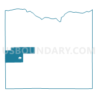
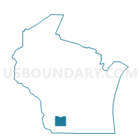
EDEN - T 1 Voting District, Iowa County, Wisconsin
About
Outline

Summary
| Unique Area Identifier | 694088 |
| Name | EDEN - T 1 Voting District |
| County | Iowa County |
| State | Wisconsin |
| Area (square miles) | 35.33 |
| Land Area (square miles) | 35.21 |
| Water Area (square miles) | 0.12 |
| % of Land Area | 99.67 |
| % of Water Area | 0.33 |
| Latitude of the Internal Point | 42.99810320 |
| Longtitude of the Internal Point | -90.35070210 |
Maps

Graphs
Select a template below for downloading or customizing gragh for EDEN - T 1 Voting District, Iowa County, Wisconsin


Neighbors
Neighoring Voting District (by Name) Neighboring Voting District on the Map
- CLIFTON - T 1 Voting District, Grant County, WI
- Cobb - V 1 Voting District, Iowa County, WI
- DODGEVILLE - T 2 Voting District, Iowa County, WI
- HIGHLAND - T 2 Voting District, Iowa County, WI
- LINDEN - T 1 Voting District, Iowa County, WI
- LINDEN - T 2 Voting District, Iowa County, WI
- MIFFLIN - T 2 Voting District, Iowa County, WI
- Monfort - V 1 Voting District, Grant County, WI
- Montfort - V 2 Voting District, Iowa County, WI
- WINGSVILLE - T 1 Voting District, Grant County, WI
Top 10 Neighboring County Subdivision (by Population) Neighboring County Subdivision on the Map
- Dodgeville town, Iowa County, WI (1,708)
- Linden town, Iowa County, WI (847)
- Highland town, Iowa County, WI (750)
- Montfort village, Grant County, WI (622)
- Mifflin town, Iowa County, WI (585)
- Cobb village, Iowa County, WI (458)
- Clifton town, Grant County, WI (385)
- Wingville town, Grant County, WI (357)
- Eden town, Iowa County, WI (355)
- Montfort village, Iowa County, WI (96)
Top 10 Neighboring Place (by Population) Neighboring Place on the Map
Top 10 Neighboring Unified School District (by Population) Neighboring Unified School District on the Map
- Dodgeville School District, WI (8,363)
- Iowa-Grant School District, WI (4,427)
- Highland School District, WI (1,605)
Top 10 Neighboring State Legislative District Lower Chamber (by Population) Neighboring State Legislative District Lower Chamber on the Map
Top 10 Neighboring State Legislative District Upper Chamber (by Population) Neighboring State Legislative District Upper Chamber on the Map
Top 10 Neighboring 111th Congressional District (by Population) Neighboring 111th Congressional District on the Map
Top 10 Neighboring Census Tract (by Population) Neighboring Census Tract on the Map
- Census Tract 9606, Grant County, WI (3,784)
- Census Tract 9601, Grant County, WI (3,656)
- Census Tract 9503, Iowa County, WI (3,248)
- Census Tract 9502, Iowa County, WI (3,147)